East Australian Volcanism – interaction of plumes and subduction remnants
 Author links open overlay panelB.L.N.KennettD.R.Davies
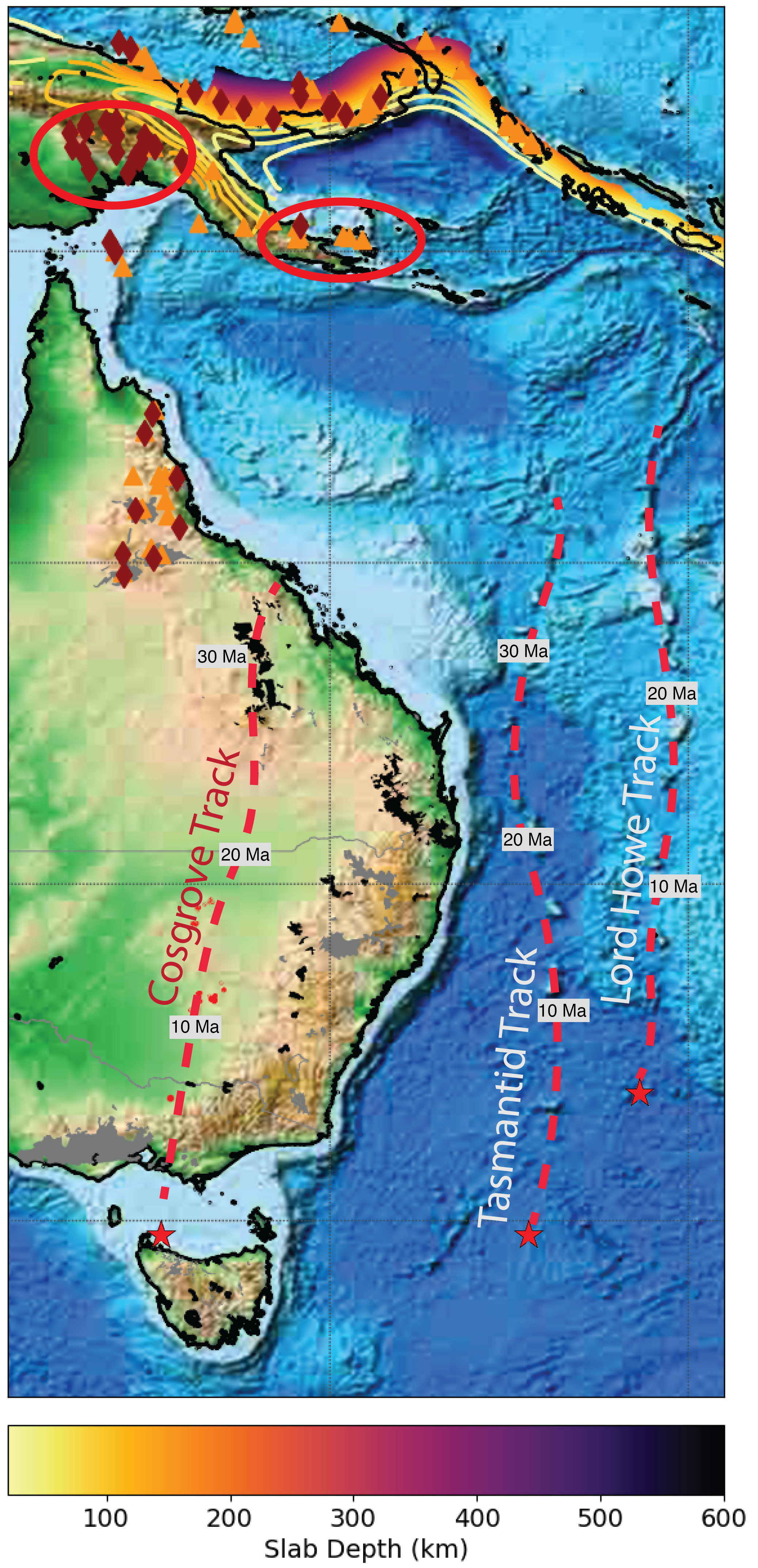
Eastern Australia hosts a wide range of volcanic edifices, ranging from localised outcrops to lava fields and central volcanoes (Figure 1). In general, the older volcanics are in the north with distinct tracks of decreasing age to the south (see Figure 1 and, e.g., Davies et al., 2015). Similar age profiles are seen for two lines of seamounts through the Tasman Sea (e.g., Seton et al., 2019). This pattern of age progression reflects the rapid motion of the Australian Plate to the north (~ 7 cm/yr) over apparently stationary sources of volcanic material.
An exception to the patterns of age variation is the intra-plate volcanism in NE Australia, the eastern Highlands of New Guinea and along the Papuan Peninsula that has been reasonably continuous over the Pliocene and Quaternary, despite the northward movement of the Australian plate in this time frame. This volcanic zone lies slightly to the east of a large step in lithospheric thickness associated with the thick North Australian craton, which extends into New Guinea.
Seismological results can help with the understanding of the structural setting, because seismic wavespeed decreases with increasing temperature (Kennett & Davies, 2020). Hot plume material will appear slow, while cold subduction related structures have relatively fast wavespeeds. Over the last 100 Ma there has been a complex pattern of plate boundaries in the region now occupied by eastern Australia and its surroundings with many different phases of subduction. A variety of fast wavespeed features have been identified from P wave tomography by van de Meer et al. (2018) and these are corroborated by S wave results (Kennett & Gorbatov, 2004).
In a global model of S wavespeed, derived mostly from the inversion for seismic waveforms, French & Romanowicz (2015) have imaged extensive areas of reduced wavespeed just above the core-mantle boundary (at ~2800 km depth). Most of these slow-wavespeed features tie to near vertical conduits extending to 1000 km depth, but that near the Coral Sea has no obvious extensive ‘hotspot’ volcanism. Yet, we have the distinctive NE Australian and PNG volcanoes in the immediate vicinity. How then does the structure at depth link to the near surface?
To provide an independent assessment of structure we have constructed a composite tomographic model that allows us to provide high resolution images of subduction related features (Kennett & Gorbatov, 2004) and a robust rendering of long-wavelength deeper structure from the model S40RTS (Ritsema et al., 2011). There is a good correspondence in the imaged features with those in the latest high- resolution model GLAD-25 from waveform inversion (Lei et al., 2020) which has better resolution at higher southern latitudes than French & Romanowicz (2015). All three models agree in the neighbourhood of the Coral Sea.
The seismic results indicate that the passage of hot material from the lower mantle is impeded by complex fast wavespeed zones above 1000 km depth (Figures 2, 3). These subduction remnants have been in place for the last 20 Ma or more. They provide a complex network of barriers in 3-D, through which we hypothesise that a small amount of hot material has been able to penetrate. The Australian continent arrived in this region at around 10 Ma, bringing the lithospheric edge into the direct influence of the masked mantle plume at depth. The rising material that has penetrated the maze of subduction remnants has interacted with the craton edge to guide the material to the surface where it has erupted.
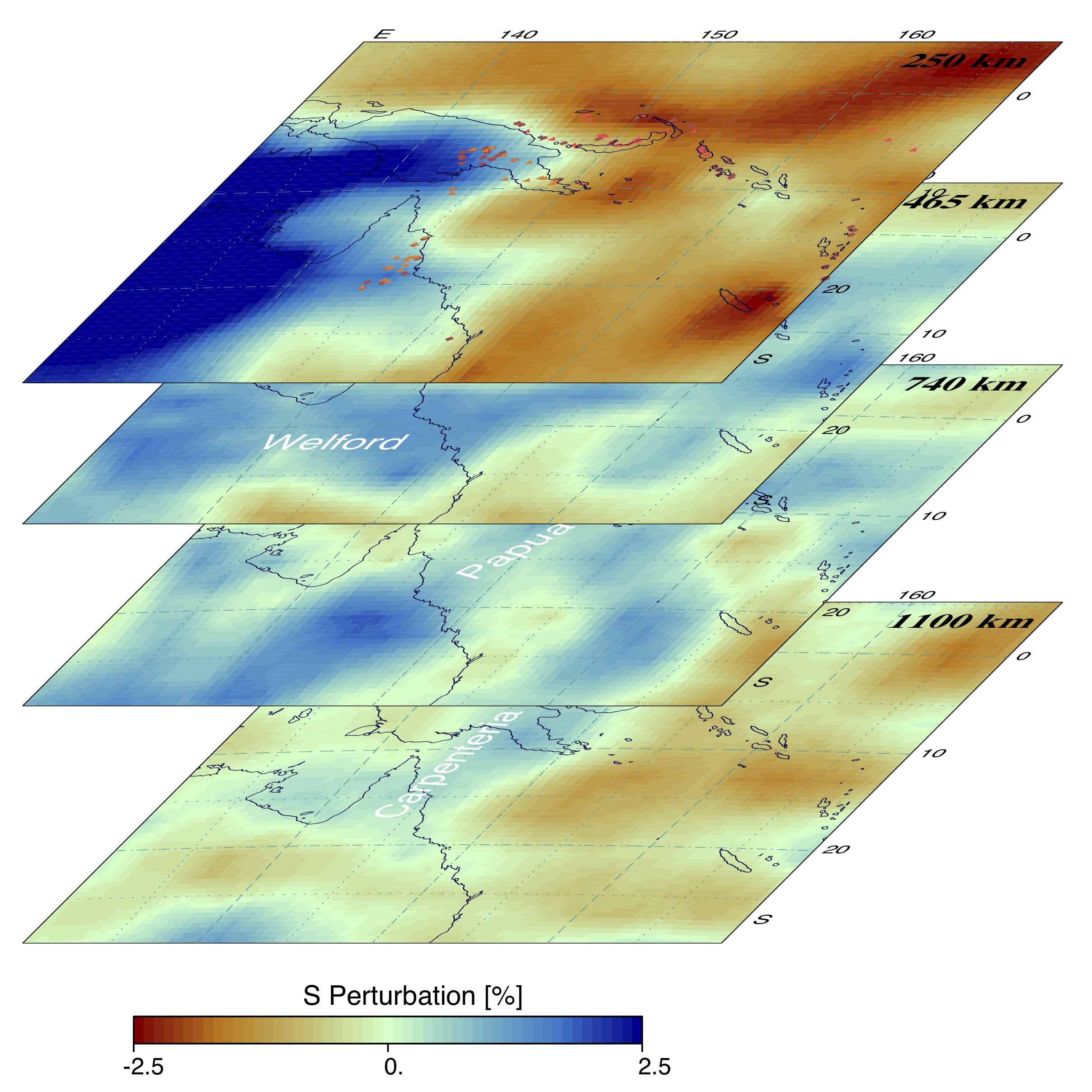
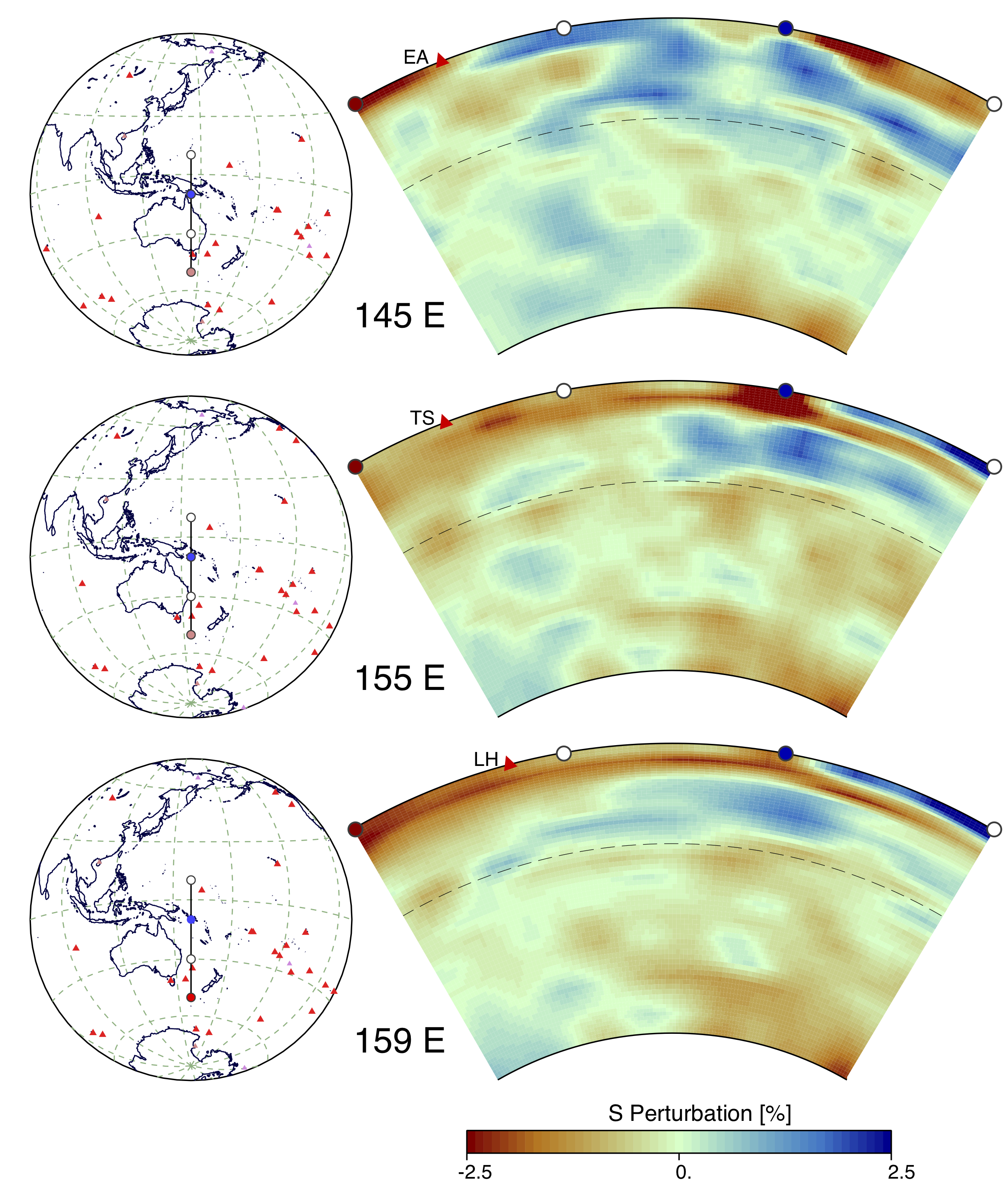
What then is the origin of the distinctive age-progressive chains of volcanism to the south? It seems likely that they are again modulated by the presence of the remnants of former subducted slabs. Van der Meer et al. (2018) identify two significant subduction elements to the south: the Lake Eyre slab (depth range 750-1250 km, likely age 75-50 Ma) and the South Loyalty Basin slab (depth range 1000-1250 km, likely age 60 -30 Ma).
The current ends of the Cosgrave track (EA) and the Tasman Sea track (TS) both lie above the southern edge of the Lake Eyre feature. The Lord Howe track lies just beside the South Loyalty remnant. These slab remnants will have remained essentially fixed in the mantle for at least the last 30 Ma as the Australian plate has moved over the top. Thus, material from depth finding its way around the edges of the remnant slabs would emerge at an approximately constant location that would appear to move south as the Australian plate progresses to the North. The differences in age between the oldest materials associated with the Tasman Sea and Lord Howe hotspots (Seton et al., 2019) may well be linked to the timing of the insertion of the subducted plates into the path of rising mantle plumes.
Acknowledgments:
This work was supported in part by Australian Research Council Discovery Project DP170100058.
References:
Davies D.R., Rawlinson N., Iaffaldano G., Campbell I.H., 2015. Lithospheric controls on magma composition along Earth’s longest continental hotspot track. Nature 525, 511–514.
French S.W., Romanowicz B., 2015. Broad plumes rooted at the base of the Earth’s mantle beneath major hotspots. Nature 525, 95–99.
Hayes G.P., Moore G.L., Portner D.E., Hearne M., Flamme H., Furtney M., Smoczyk G.M., 2018. Slab2, a comprehensive subduction zone geometry model. Science 362, 58--61.
Kennett B.L.N., Gorbatov A., 2004. Seismic heterogeneity in the mantle - strong shear wave signature of slabs. Physics of the Earth and Planetary Interiors 146, 88–100.
Kennett B.L.N., Davies D.R., 2021. Intra-plate volcanism in North Queensland and eastern new Guinea: A cryptic mantle plume? Gondwana Research 79, 209–216.
Lei W. et al., 2020. Global adjoint tomography—model GLAD-M25, Geophysical Journal International 223, 1–21.
Ritsema J., van Heijst H.J., Deuss A., Woodhouse J.H., 2011. S40RTS: a Degree–40 shear velocity model for the mantle from new Rayleigh wave dispersion, teleseismic traveltimes, and normal–mode splitting function measurements. Geophysical Journal International 184, 1223–1236.
Seton M., Williams S., Mortimer N., Meffre S., Micklethwaite S., Zahirovic S., 2019. Magma production along the Lord Howe Seamount Chain, northern Zealandia. Geological Magazine 156,1605–1617.
van der Meer, D. G., van Hinsbergen, D. J. J., Spakman, W., 2018. Atlas of the underworld: Slab remnants in the mantle, their sinking history and a new outlook on lower mantle viscosity. Tectonophysics 723, 309–448