Floods And Covid-19 In Timor-Leste Reveal Risks Of Interacting Hazards
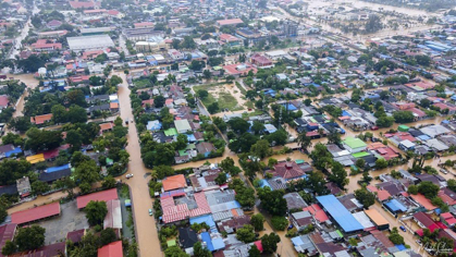
Flooding in central Dili, Timor-Leste (credit: Machel Silveira).
Contributing Authors: Mark Quigley1, Brendan Duffy1, Oktoviano Tilman de Jesus2, Lisa Palmer1, Januka Attanayake1, Claire Vincent1, Andrew King1, Demetrio Amaral Carvalho3, Josh Trindade4, Ian Rutherfurd1
- The School of Geography, Earth and Atmospheric Sciences, University of Melbourne
- Vice president - Instituto do Petroleo e Geologia, Dili, Timor-Leste
- Secretary of State for the Environment, Dili, Timor-Leste
- Government of RDTL and Independent Researcher, Dili, Timor-Leste
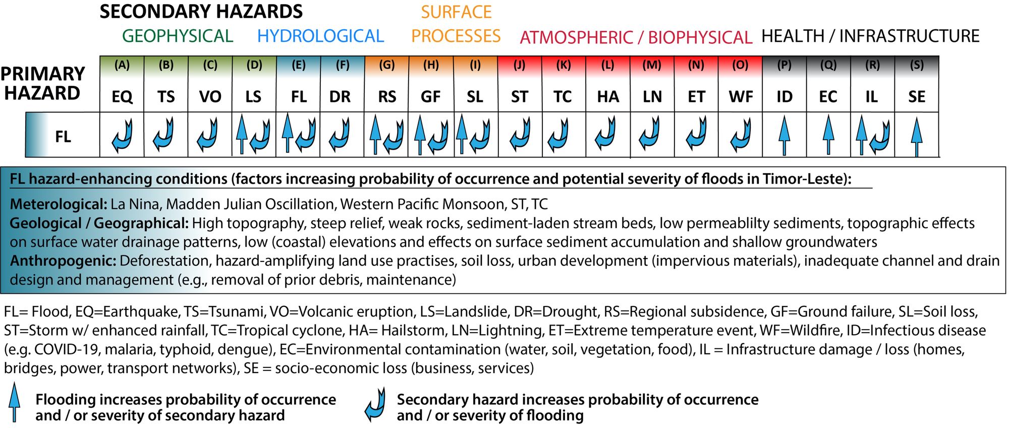
The cascading effects of interacting hazards can be better anticipated and integrated with other measures to reduce risks to human life and infrastructure from these extreme events.
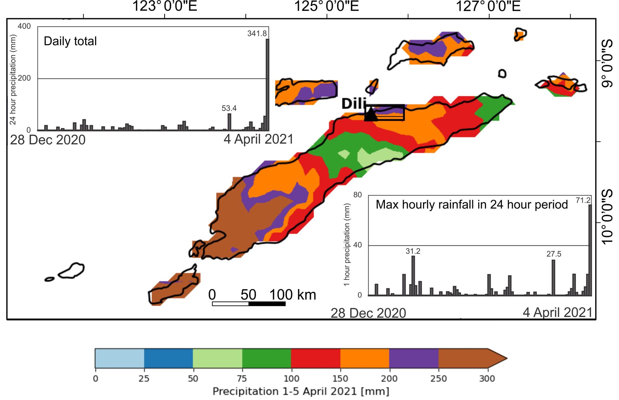
Heavy tropical rainfall battered Timor-Leste and its neighbouring Indonesian islands over the Easter period. The meterological station in Timor-Leste’s densely populated capital Dili recorded more than 400 mm rainfall from April 3rd to 4th. Intense rains of up to 70 mm per hour swelled mountainous catchments and sent tidal waves of floodwaters and debris into populated areas. Recent reports indicate at least 42 fatalities and displacement of 13,554 people across the nation.
Adverse impacts include food shortages, limited access to clean water and essential supplies, damage to critical infrastructure and lifelines, and reduced access to affected communities. The concurrence of the flood with ascending rates of COVID-19 infections has amplified this major crisis and highlights the global risks of interacting hazards.
A recipe for flood hazards
Several natural and human factors combine to enhance flood hazard in Timor Leste.
The West Pacific Monsoon, Madden Julian Oscillation and La Niña conspire to create ideal conditions for increased rainfall and tropical storms in the region. All of these conditions were in place for the 2021 floods.
Timor-Leste’s mountainous topography (see image above) enhances orographic rainfall and creates steep stream systems that rapidly transfer flood waters into adjacent populated areas. Weak rocks and steep catchments are highly susceptible to landslides. Coalescing, geologically young (<5000 year) sedimentary fans direct flood waters and sediment into central Dili. Rampant deforestation and development increase soil erosion and stream discharges during high rainfall events.
Rapid and largely uncoordinated population growth, particularly in Dili, has concentrated vulnerable populations into regions of high exposure to flood hazards, such as flood plains and low-elevation coastal areas.
Flood hazard is further increased by the proliferation of concrete structures that reduce surface water infiltration, the widespread use of multi-pylon concrete bridges that trap flood debris, and inadequate design and maintenance of urban drainage channels that are perennially choked with sediment and urban waste and thus do not function well in flood conditions. Groundwater extraction in Dili for urban use causes surface subsidence that further amplifies coastal and flood hazards.
Dili has been badly impacted by numerous large floods prior to this event, most recently in March 2020.
Interacting hazards: floods and COVID-19
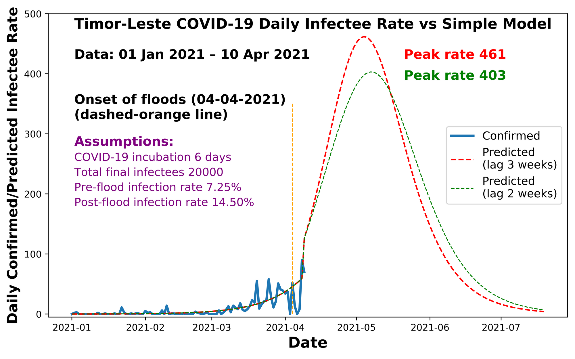
The difference this time is the concurrence of flooding with ascending community COVID-19 infections. In response to flood impacts, authorities have temporarily lifted COVID-19 restrictions that were formerly in place. Flood-affected vulnerable residents have been amalgamated into group shelters, often via evacuations where social distancing and masking are not practicable. Flood damage has reduced power and access to COVID-19 crisis and treatment centres and has affected the ongoing COVID-19 vaccination program.

Our research shows that temporary (i.e., 2-3 weeks) relaxations of COVID-19 restrictions during natural disasters, as may be required to balance COVID-19 risks and protocols with disaster response and recovery operations, can cause large spikes in COVID-19 infection rates. Increasing risks of infectious disease are well known to accompany flood disasters, and form part of a complex hazard chain involving many other hazards of natural and anthropogenic origin.
What can be done?
Potential solutions to complex problems like interacting hazards are more likely to be effective when they produced in partnerships between international and local experts, diverse support agencies, and affected communities.
Our research highlights steps that can be taken to enhance disaster preparedness and response in our COVID-19 world. This includes the importance of developing and implementing pandemic and natural hazard hybrid models to better prepare for the types of interacting hazards that are likely to occur.
Beneficial aspects of disaster planning strategies and resourcing may include the use of remote coordination platforms, localisation of response efforts and resources, increased availability of evacuation centres with capacity for social distancing, increased availability of personal protective equipment and medical equipment (e.g. respirators), and potential mobility of humanitarian actors, volunteers and medical staff that could respond to natural disasters in COVID-affected regions.
Re-instating strict COVID-19 mitigation measures as rapidly as possible after concurrent disasters is critical for reducing the impacts of both disasters. Our modelling shows that infection rates under temporarily unmitigated conditions ascend rapidly towards completely unmitigated scenarios within weeks.
Finally, the implementation and enhancement of culturally-informed catchment management practises, risk-based land-use planning practises, and post-disaster urban clean-up practises can help reduce the amplifying effects of prior disasters on future disasters. This is critical in developing nations such as Timor-Leste, where continued urban development continues to amplify the exposure, vulnerability, and risks from hazards.